After secondary migration in carrier beds, oil finally collects in a trap. The fundamental characteristic of a trap is an upward convex form of porous and permeable reservoir rock that is sealed above by a denser, relatively impermeable cap rock (e.g., shale or evaporites). The trap may be of any shape, the critical factor being that it is a closed, inverted container. A rare exception is hydrodynamic trapping, in which high water saturation of low-permeability sediments reduces hydrocarbon permeability to near zero, resulting in a water block and an accumulation of petroleum down the structural dip of a sedimentary bed below the water in the sedimentary formation.

Hydrocarbon Traps
A hydrocarbon reservoir has a distinctive shape, or configuration, that prevents the escape of hydrocarbons that migrate into it. Geologists classify reservoir shapes, or traps, into two types; structural traps: a deformation in the rock layer that contains the hydrocarbons. Examples; fault traps and anticlinal traps. stratigraphic traps:form when other beds seal a reservoir bed or when the permeability changes within the reservoir bed itself. combination trap:this happens when more than one kind of trap forms.
Structural traps
Traps can be formed in many ways. Those formed by tectonic events, such as folding or faulting of rock units, are called structural traps. The most common structural traps are anticlines, upfolds of strata that appear as ovals on the horizontal planes of geologic maps. About 80 percent of the world’s petroleum has been found in anticlinal traps. Most anticlines were produced by lateral pressure, but some have resulted from the draping and subsequent compaction of accumulating sediments over topographic highs. The closure of an anticline is the vertical distance between its highest point and the spill plane, the level at which the petroleum can escape if the trap is filled beyond capacity. Some traps are filled with petroleum to their spill plane, but others contain considerably smaller amounts than they can accommodate on the basis of their size.
Another kind of structural trap is the fault trap. Here, rock fracture results in a relative displacement of strata that forms a barrier to petroleum migration. A barrier can occur when an impermeable bed is brought into contact with a carrier bed. Sometimes the faults themselves provide a seal against “updip” migration when they contain impervious clay gouge material between their walls. Faults and folds often combine to produce traps, each providing a part of the container for the enclosed petroleum. Faults can, however, allow the escape of petroleum from a former trap if they breach the cap rock seal.
Other structural traps are associated with salt domes. Such traps are formed by the upward movement of salt masses from deeply buried evaporite beds, and they occur along the folded or faulted flanks of the salt plug or on top of the plug in the overlying folded or draped sediments.
Anticline Trap
An anticline is an example of rocks which were previously flat, but have been bent into an arch. Oil that finds its way into a reservoir rock that has been bent into an arch will flow to the crest of the arch, and get stuck (provided, of course, that there is a trap rock above the arch to seal the oil in place).

A cross section of the Earth showing typical Anticline Traps. Reseroir rock that isn't completely filled with oil also contains large amounts of salt water.
Fault Trap
Fault traps are formed by movement of rock along a fault line. In some cases, the reservoir rock has moved opposite a layer of impermeable rock. The impermeable rock thus prevents the oil from escaping. In other cases, the fault itself can be a very effective trap. Clays within the fault zone are smeared as the layers of rock slip past one another. This is known as fault gouge.
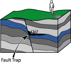
A cross section of rock showing a fault trap - in this case, an example of gouge. This is because the reservoir rock on both sides of the fault would be connected, if not for the fault seperating the two. In this example, it is the fault itself that is trapping the oil.
Salt Dome Trap
Salt is a peculiar substance. If you put enough heat and pressure on it, the salt will slowly flow, much like a glacier that slowly but continually moves downhill. Unike glaciers, salt which is buried kilometers below the surface of the Earth can move upward until it breaks through to the Earth's surface, where it is then dissolved by ground- and rain-water. To get all the way to the Earth's surface, salt has to push aside and break through many layers of rock in its path. This is what ultimately will create the oil trap.

Here we see salt that has moved up through the Earth, punching through and bending rock along the way. Oil can come to rest right up against the salt, which makes salt an effective trap rock. However, many times, the salt chemically changes the rocks next to it in such a way that oil will no longer seep into them. In a sense, it destroys the porosity of a reservoir rock.
Stratigraphic Traps
A stratigraphic trap accumulates oil due to changes of rock character rather than faulting or folding of the rock. The term "stratigraphy" basically means "the study of the rocks and their variations". One thing stratigraphy has shown us is that many layers of rock change, sometimes over short distances, even within the same rock layer. As an example, it is possible that a layer of rock which is a sandstone at one location is a siltstone or a shale at another location. In between, the rock grades between the two rock types. From the section on reservoir rocks, we learned that sandstones make a good reservoir because of the many pore spaces contained within. On the other hand, shale, made up of clay particles, does NOT make a good reservoir, because it does not contain large pore spaces. Therefore, if oil migrates into the sandstone, it will flow along this rock layer until it hits the low-porosity shale. Voilà, a stratigraphic trap is born!

An example of a stratigraphic trap
The above series of diagrams is an attempt to illustrate a type of stratigraphic trap. In the diagram at the upper left, we see a river that is meandering. As it does so, it deposits sand along its bank. Further away from the river is the floodplain, where broad layers of mud are deposited during a flood. Though they seem fairly constant, rivers actually change course frequently, eventually moving to new locations. Sometimes these new locations are miles away from their former path.
In the diagram at the upper right, we show what happens when a river changes its course. The sand bars that were deposited earlier are now covered by the mud of the new floodplain. These lenses of sand, when looked at from the side many years later (the bottom diagram), become cut off from each other, and are surrounded by the mud of the river's floodplain - which will eventually turn to shale. This makes for a perfect stratigraphic trap.


No comments:
Post a Comment