Sunday, November 17, 2013

Hydrocarbon Exploration


In the first stage of the search for hydrocarbon-bearing rock formations, geological maps are reviewed in desk studies to identify major sedimentary basins. Aerial photography may
then be used to identify promising landscape formations such as faults or anticlines. More detailed information is assembled using a field geological assessment, followed by one of three main survey methods: magnetic, gravimetric and seismic. The Magnetic Method depends upon measuring the variations in intensity of the magnetic field which reflects the magnetic character of the various rocks present, while the Gravimetric Method involves the measurements of small variations in the gravitational field at the surface of the earth. Measurements are made, on land and at sea, using an aircraft or a survey ship respectively. A seismic survey is the most common assessment method and is often the first field activity undertaken. The Seismic Method is used for identify- ing geological structures and relies on the differing reflective properties of soundwaves to various rock strata, beneath ter- restrial or oceanic surfaces. An energy source transmits a pulse of acoustic energy into the ground which travels as a wave into the earth. At each point where different geological strata exist, a part of the energy is transmitted down to deeper layers within the earth, while the remainder is reflected back to the surface. Here it is picked up by a series of sensitive receivers called geophones or seismometers on land, or hydrophones submerged in water. Special cables transmit the electrical signals received to a mobile laboratory, where they are amplified and filtered and then digitized and recorded on magnetic tapes for interpretation. Dynamite was once widely used as the energy source, but environmental considerations now generally favour lower- energy sources such as vibroseis on land (composed of a gen- erator that hydraulically transmits vibrations into the earth) and the air gun (which releases compressed air) in offshore exploration. In areas where preservation of vegetation cover is important, the shot hole (dynamite) method is preferable to vibroseis.
 
seismic survey
 
There are three (3) primary methodologies used to find hydrocarbons in the subsurface: Geophysical, Remote Sensing, and Wildcatting.
 
GEOPHYSICAL SURVEYS
 Geophysical techniques used for petroleum exploration utilize equipment to measure such things as: electrical currents, gravitational and magnetic anomalies, heat flow, geochemical relationships, and density variations from deep within the earth. Each technique records a different set of characteristics which can be used to locate hydrocarbons beneath the surface of the earth.
 Seismic surveys use vibration (induced by an explosive charge or sound generating equipment) to provide a picture of subterranean rock formations at depth, often as deep as 30,000 feet below ground level (BGL). This is accomplished by generating sound waves downward into the earth's crust which reflect off various boundaries between different rock strata. On land, the sound waves are generated by small explosive charges embedded in the ground or by vibrator trucks, sometimes referred to as thumpers which shake the ground with hydraulically driven metal pads.  The human ear can barely hear the thump, but the frequency generated penetrates the earth's crust. The echoes are detected by electronic devices called geophones which receive the reflected sound waves and the data are recorded on magnetic tape which is printed to produce a two-dimensional graphic illustrating the subsurface geology. 
 Offshore surveys  are conducted in a slightly different manner. Boats tow cables containing hydrophones in the water, which is similar to geophones on land. Sound waves use to be created by dynamite, but this method killed a variety of sea life. The most acceptable method today is to generate sound waves using pulses of compressed air which creates large bubbles that burst beneath the water surface creating sound. The sound waves travel down to the sea floor, penetrate the rocks beneath, and return to the surface where they are intercepted by the hydrophones. Processing and illustration is the same as the dry land method.
 In this type of survey, sound waves are sent into the earth where they are reflected by the different layers of rock. The time taken for them to return to the surface is measured as a function of time. This measurement reveals how deep the reflecting layers are; the greater the time interval, the deeper the rock layer. Moreover, this technique also can determine what type of rock is present because different rocks transmit sound waves differently.
 The most sophisticated seismic surveys are three-dimensional (3-D). The recorded data is processed by computer and the results are a detailed, 3-D picture of the formations and structures below the surface. The process is expensive, on the order of $30,000 per mile (Satterwhite, pers comm). But drilling a well can cost multiple millions of dollars, so time and money spent on accurate seismic surveys can be a good investment since it helps locate prospects and minimize dry holes. In general, seismic surveys can be carried out without disturbing people or damaging the environment, whether they are being conducted on land  or water.  It is a primary tool used by exploration geologists to locate [hydrocarbon] prospects.
 There are a number of other geophysical techniques such as magnetometers and gravimeters, and geochemical prospecting, a relatively new technique. A magnetometer is a device that is pulled behind an airplane  on a long cable that detects variations in the earth's magnetic field. Sedimentary rocks generally have low magnetic properties compared to other rock types. A gravimeter  measures minute differences in the pull of gravity at the earth's surface. Mapping these differences reveals large masses of dense subsurface rock which allows geologists to have a better idea of the structures below ground. Geochemical prospecting uses sensitive instruments to detect minute quantities of gases that seep upward from petroleum deposits. This is a relatively new technique, but is one that is gaining wider acceptance.
 
Magnetic survey
REMOTE SENSING
 Remote Sensing (RS) is the use of aerial photographs to locate and map surface features. Increasing use of satellite imagery  is being made because it shows large areas on the surface of the earth. Even though the photographs are taken form several hundred miles up in space, they are able to show features only a few feet in size. And satellite imagery not only indicates what the human eye can see, but they can also reveal subtle variations in soil moisture, mineral and vegetation distribution, and soil type, all of which are import pieces to the exploration puzzle.
 Once an area is selected and the satellite imagery obtained, the exploration geologist utilizes mapping techniques to produce a geologic map (a map that indicates geological structures by using conventional symbols) for the area. The series of lines and arrows indicate the type of structure that exists at the surface. For example, , taken in November 1972 by a NASA satellite orbiting over 500 miles out in space, shows the surface topography very clearly for an area in Southeastern Oklahoma known as the Ouachita Mountains. These mountains are comprised of folded and faulted Paleozoic strata which are buried beneath younger sediments toward the south. These mountains are made of a combination of structures called anticlines, synclines, and faults, all of which form various types of hydrocarbon traps.
 Another type of RS technique uses imagery that was created from a radar looking at the ground called Side Looking Airborne Radar (SLAR). Some of this imagery is flown with an aircraft while some of it is onboard satellites or the US Space Shuttle. It produces an image much like a photograph that also shows earth structure at the surface. This figure  is an area in South America that has never been explored. Until this SLAR image was made, there were no accurate maps of the region because the area is usually covered by clouds. But now, there are new opportunities based on this image.
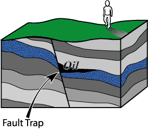
 These types of maps allow geologists to determine where hydrocarbons might be located. Remember in Chapter 4, we discussed various types of structural traps. Anticlines are ideal structural traps while synclines do not tend to trap hydrocarbons. Thus both Figures  and  above show anticlines that will aid in the development of new prospects.
 
Remote sensing survey
WILDCAT
 A wildcat well is one that is drilled in a new area where no other wells exist and generally with scant information. It is drilled in an effort to locate undiscovered accumulation of hydrocarbons. About 1 in 10 wildcat wells strike oil or gas, but only one in perhaps 50 locate economically significant amounts. Many wildcat wells are drilled on a hunch, intuition, or a small amount of geology. Many times they are based on photography and experience in a particular area. Wildcat wells are generally drilled at a smaller diameter than normal because this saves money (the average onshore well at present costs about 10 MM dollars to drill).
 One of the earliest exploration tools was referred to as Creekology,  discussed earlier. But recent technological advances have lead to computer-enhanced capabilities using laptops that has had a major affect on the petroleum industry. New seismic techniques, for example, have created more mobile, less expensive, and easier to operate exploration tools that has created a wealth of information designed specifically for hydrocarbon exploration. Field equipment is smaller, lighter, more accurate and reliable and provides far greater detailed data.
 But the basic tool needed for the search for hydrocarbons still remains a knowledge of the Earth and earth processes of formation, lithology, and structure. But even with all of this, wildcat wells are still drilled, but their success rate is substantially lower than a well spudded in (to begin a new well) using all of the geological tools available.
 
Read more »

Friday, November 15, 2013

Hydrocarbon Trap

 
After secondary migration in carrier beds, oil finally collects in a trap. The fundamental characteristic of a trap is an upward convex form of porous and permeable reservoir rock that is sealed above by a denser, relatively impermeable cap rock (e.g., shale or evaporites). The trap may be of any shape, the critical factor being that it is a closed, inverted container. A rare exception is hydrodynamic trapping, in which high water saturation of low-permeability sediments reduces hydrocarbon permeability to near zero, resulting in a water block and an accumulation of petroleum down the structural dip of a sedimentary bed below the water in the sedimentary formation.
 
Hydrocarbon Traps
 
A hydrocarbon reservoir has a distinctive shape, or configuration, that prevents the escape of hydrocarbons that migrate into it. Geologists classify reservoir shapes, or traps, into two types; structural traps: a deformation in the rock layer that contains the hydrocarbons. Examples; fault traps and anticlinal traps. stratigraphic traps:form when other beds seal a reservoir bed or when the permeability changes within the reservoir bed itself. combination trap:this happens when more than one kind of trap forms.
 
Structural traps
Traps can be formed in many ways. Those formed by tectonic events, such as folding or faulting of rock units, are called structural traps. The most common structural traps are anticlines, upfolds of strata that appear as ovals on the horizontal planes of geologic maps. About 80 percent of the world’s petroleum has been found in anticlinal traps. Most anticlines were produced by lateral pressure, but some have resulted from the draping and subsequent compaction of accumulating sediments over topographic highs. The closure of an anticline is the vertical distance between its highest point and the spill plane, the level at which the petroleum can escape if the trap is filled beyond capacity. Some traps are filled with petroleum to their spill plane, but others contain considerably smaller amounts than they can accommodate on the basis of their size.
Another kind of structural trap is the fault trap. Here, rock fracture results in a relative displacement of strata that forms a barrier to petroleum migration. A barrier can occur when an impermeable bed is brought into contact with a carrier bed. Sometimes the faults themselves provide a seal against “updip” migration when they contain impervious clay gouge material between their walls. Faults and folds often combine to produce traps, each providing a part of the container for the enclosed petroleum. Faults can, however, allow the escape of petroleum from a former trap if they breach the cap rock seal.
Other structural traps are associated with salt domes. Such traps are formed by the upward movement of salt masses from deeply buried evaporite beds, and they occur along the folded or faulted flanks of the salt plug or on top of the plug in the overlying folded or draped sediments.
Anticline Trap
An anticline is an example of rocks which were previously flat, but have been bent into an arch. Oil that finds its way into a reservoir rock that has been bent into an arch will flow to the crest of the arch, and get stuck (provided, of course, that there is a trap rock above the arch to seal the oil in place).
 
 
A cross section of the Earth showing typical Anticline Traps. Reseroir rock that isn't completely filled with oil also contains large amounts of salt water.
 
Fault Trap
Fault traps are formed by movement of rock along a fault line. In some cases, the reservoir rock has moved opposite a layer of impermeable rock. The impermeable rock thus prevents the oil from escaping. In other cases, the fault itself can be a very effective trap. Clays within the fault zone are smeared as the layers of rock slip past one another. This is known as fault gouge.
 
A cross section of rock showing a fault trap - in this case, an example of gouge. This is because the reservoir rock on both sides of the fault would be connected, if not for the fault seperating the two. In this example, it is the fault itself that is trapping the oil.
 
Salt Dome Trap
Salt is a peculiar substance. If you put enough heat and pressure on it, the salt will slowly flow, much like a glacier that slowly but continually moves downhill. Unike glaciers, salt which is buried kilometers below the surface of the Earth can move upward until it breaks through to the Earth's surface, where it is then dissolved by ground- and rain-water. To get all the way to the Earth's surface, salt has to push aside and break through many layers of rock in its path. This is what ultimately will create the oil trap.
 
Here we see salt that has moved up through the Earth, punching through and bending rock along the way. Oil can come to rest right up against the salt, which makes salt an effective trap rock. However, many times, the salt chemically changes the rocks next to it in such a way that oil will no longer seep into them. In a sense, it destroys the porosity of a reservoir rock.
 
Stratigraphic Traps
A stratigraphic trap accumulates oil due to changes of rock character rather than faulting or folding of the rock. The term "stratigraphy" basically means "the study of the rocks and their variations". One thing stratigraphy has shown us is that many layers of rock change, sometimes over short distances, even within the same rock layer. As an example, it is possible that a layer of rock which is a sandstone at one location is a siltstone or a shale at another location. In between, the rock grades between the two rock types. From the section on reservoir rocks, we learned that sandstones make a good reservoir because of the many pore spaces contained within. On the other hand, shale, made up of clay particles, does NOT make a good reservoir, because it does not contain large pore spaces. Therefore, if oil migrates into the sandstone, it will flow along this rock layer until it hits the low-porosity shale. Voilà, a stratigraphic trap is born!
 
 
An example of a stratigraphic trap
 
The above series of diagrams is an attempt to illustrate a type of stratigraphic trap. In the diagram at the upper left, we see a river that is meandering. As it does so, it deposits sand along its bank. Further away from the river is the floodplain, where broad layers of mud are deposited during a flood. Though they seem fairly constant, rivers actually change course frequently, eventually moving to new locations. Sometimes these new locations are miles away from their former path.
In the diagram at the upper right, we show what happens when a river changes its course. The sand bars that were deposited earlier are now covered by the mud of the new floodplain. These lenses of sand, when looked at from the side many years later (the bottom diagram), become cut off from each other, and are surrounded by the mud of the river's floodplain - which will eventually turn to shale. This makes for a perfect stratigraphic trap.
Read more »

Wednesday, November 13, 2013

Hydrocarbon Migration


There are two types of migration when discussing the movement of petroleum, primary and secondary. Primary migration refers to the movement of hydrocarbons from source rock into reservoir rock and it is this type that the following discussion refers to. Secondary migration refers to the subsequent movement of hydrocarbons within reservoir rock; the oil and gas has left the source rock and has entered the reservoir rock. This occurs when petroleum is clearly identifiable as crude oil and gas although the gas may be dissolved in the oil. Buoyancy of the hydrocarbons occurs because of differences in densities of respective fluids and in response to differential pressures in reservoir rock.


The general process is as follows.
With increasing temperature the organic matter produces hydrocarbons.  This increase in temperature is simply a set result of burial of the rock.
As hydrocarbons are generated the gasses and liquids plus the remaining organic matter actually try to occupy a greater volume of the rock than the original organic matter occupied.  Because this happens to all of the organic particles in the rock and there are literally millions of such particles in a source rock, there is a definite increase in pressure within the rock.
This internal pressure increase due to the generation of hydrocarbons imposes an increased pressure on the fluids that occur in the pore spaces, that exist between the mineral grains.  This is called the pore fluid pressure.  A number of calculations have been made that show the amount of volume increase.  For a source rock with a TOC of 1% wt and assuming a 10% porosity, a volume increase in the organic matter due to hydrocarbon generation will be about 5% of the pore space.  Looked at in another way a 1% TOC is a source rock will occupy 2.5% of the volume of the rock and will generate hydrocarbons that occupy an additional  0.25% volume of the rock [Barker, 1980:25].
Clearly if one can cause an increase in the internal pressure within the source rock then a mechanism exists for the expulsion of any gaseous and liquid hydrocarbons that are generated.  One reason this idea is acceptable is it is the simplest [Occam's razor]..  It states the origin and expulsion of hydrocarbons from a source rock is a natural process that operates as the source rock is buried under more and more layers of sediments. Hunt [1977] pointed out that about 10% or less of the bitumenoids in a source rock need to migrate to produce a commercial accumulation in an associated reservoir.  As Barker [1980:25} noted this means the pressuring mechanism only need be about 10% efficient.
 
Movement as a distinct hydrocarbon liquid or gas phase, either with or without water.
Baker [1980:30] noted that at shallow depths [>6,000 feet] the only hydrocarbons present in the source rock are the biological markers. Associated with these are bacterially generated gas [biogenic gas].  Liquid hydrocarbons accumulating in shallow areas will tend to have a high content of aromatic hydrocarbons, presumably because aromatics are most soluble in water and can thus be transported further.  As the thermal generation of hydrocarbons begins [>6,000 feet] heavy oil with high NSO content tends to form.  With increasing depth [10,000 feet] thermal cracking produces a lot of low molecular weight hydrocarbons. In the deepest part of the basin liquid crude i replaced by condensate and ultimately petrogenic gas. Jones [1980:56, fig.5] presents a diagram showing the sharp drop in H/C ratio during thermal maturation of un-extracted organic matter, indicating the "ejection of the kerogen - by the kerogen", of the more hydrocarbon rich generation products. Jones [p:47] concluded that "most of the major commercial oil accumulations of the world left their source rock in a continuous oil phase". We know quite well that liquid hydrocarbons can be generated from organic matter by increasing temperature and the real question to ask is if liquid hydrocarbons did form in a specific rock body, how to they get out of the source rock into the reservoir.
Movement in solution, either with or without water.
 
Very little real-world data on the solubility of hydrocarbons under differing subsurface salinity, pressure and temperature conditions is available. Hydrocarbons do have very low solubility in water and most petroleum engineers reject solution as an important mechanism, except in special circumstances such as shallow gas fields, or elevated temperature at great depth [Tissot and Welte, 1978:296; Hunt, 1979:208-213].  It is definitely true that as peak generation approaches a source rock will contain several times the hydrocarbons required for saturation of the pore water.  As a further argument against the idea McAuliffe [1979] notes that  the molecular composition of oil bears no relationship to variations in hydrocarbon molecular solubility in water.
The solution of hydrocarbon in gas has been suggested but it is unlikely that the heavier hydrocarbons could dissolve in this way. 
 
Mechanisms connected with the origin in the source rock.
Three modes for migration of the organic component are normally suggested.
Movement as individual molecules or colloids dispersed in water.
It is possible that much of the dissolved organic matter in a source rock is not in the form of hydrocarbon but is a pre-cursor such as alcohol or an organic acid or colloidal aggregate.  These substances are more soluble than hydrocarbons [Barker, 1980:21, Tab. II].  A mechanism involving solution of a pre-cursor chemical may be operative in some circumstances for it is undoubtedly true that such materials go into solution.  Both Dickey [1975] and Magara [1980:35] rejected the colloidal aggregate ideas, partly because this would not greatly increase the solubility of the heavier hydrocarbon molecules.
Mechanisms connected with  movement in the source rock.
There are three important considerations when one examines the movement of hydrocarbons in the source rock.
Porosity of the source rock.  Both mineral grains and particulate organic matter can play a role.
Micro-pressuring in the source rock. Both micro-fracturing and aqua-thermal pressuring can be important.
Pore space chemistry of the source rock. Both desorption of water and dynamic structuring of water cab play a role.
Porosity.
 
Both grain size and pore size are related to porosity. In source rocks pore diameter is extremely small 100 angstroms at 3,000 feet and 25 angstroms at 12,000 feet].  This lower size is only slightly larger than bitumoid molecules [Hinch, 1980:7] and the old argument which precludes the possibility of continuous oil flow in fine grained source rocks due to the small pore space and capillary size is clearly not valid: as the deeper fine grain reservoirs of the Gulf of Mexico testify. It is possible that the fine pore space does stop oil leaving a source rock but in oil source rocks, which have a greater amount of organic matter, the combined effects of hydrocarbon generation and compaction cause high differential pressure effects, which more the hydrocarbons our the the source rock. 
 
Mompers [1978] discussed the distribution of particulate organic mater in source rocks.  It is important to note that POM is often located in laminations within a source rock, and the particles are larger in size than the associated clay minerals. The organic layers thus provide localized stingers or larger connecting pores exactly in the part of the source rock where hydrocarbons or their pre-cursors originate.   The heterogeneous distribution of hydrocarbons in source rocks led McAuliffe [1980:99] and Erdman [1965] to suggest hydrocarbons are generated in this organic matter and flow through it to the reservoir.  Under this idea the lower limit of 0.5% TOC in source rock would roughly represent the value below which there would be insufficient organic matter to form a 3-D network.

Micro-pressuring.
Mompers [1978] clearly outlines the characteristics of a source rock which are important in the development of micro-pathways with the rock.  The mechanism also was discussed by Snarski [1970], Dickey [1975], Magara [1978] and Tissot and Welte [1978].  Mompers' basic idea  is that as hydrocarbons are generated the increase in volume causes an increase in pressure.  At some point the pressure increase causes micro-fracturing in the rock, and the hydrocarbons migrate into the micro-fractures which lead out of the source rock.  This concept allows the hydrocarbons to migrate in a liquid phase, but does not preclude the additional or alternative migration in a pre-cursor form.  This is regarded as the main mechanism for primary migration out of the source rock.
 
Droplets, either of hydrocarbons or water, need pore space within which to migrate and if the pore space is less than the diameter of the molecule then the molecule must either deform to pass through the pore space or will block the pore space. As temperature raises with burial, the pore space becomes aqua-thermally pressured.  An example would be a source rock with 10% porosity, heated to 115oC from 85oC [which could correspond to an increased depth of burial from 10,000 feet to 14,000 feet in the Gulf Coast Basin]. Under such a change the increase in volume of the pore water will be 0.15% of the volume of the rock [Barker, 1980:25].  This increase in volume is added to the increase caused by the generation of hydrocarbons.  The result is an increase in pore fluid pressure resulting in micro-pressuring [or deformation and pushing of the oil droplets through the pore spaces].  If the source rocks are at a critical temperature then micro-pressuring could result from a very small increase in depth of burial. Hinch [1980:1] pointed out that it is difficult to explain primary expulsion of hydrocarbons via pore water expulsion during simple compaction and flushing because by the time hydrocarbons are generated in sufficient amounts most of the pore water already has been expelled by compaction and the amount of water remaining is insufficient to flush hydrocarbons from the source rock.

Pore space chemistry.
Certain minerals contain water and with increased burial the temperature and pressure increase can cause the water to be released from the minerals.  This gives an additional source of water for flushing. The clay mineral Smectite [Montmorillonite] undergoes this process. Inter-layered water is released from smectite, the resulting material reacts with potassium in the rock to form the new clay illite. This reaction may be of significance in some cases and is probably continuous from the surface to depth.
 
MECHANICS OF SECONDARY HYDROCARBON MIGRATION AND ENTRAPMENT
If an oil droplet were expelled from a source rock whose boundary was the seafloor, oil would rise through seawater as a continuous-phase droplet because oil is less dense than water and the two fluids are immiscible. The rate of rise would depend on the density difference (buoyancy) between the oil and the water phase. The main driving force then for the upward movement of oil through sea water is buoyancy. Buoyancy is also the main driving force for oil or gas migrating through water-saturated rocks in the subsurface. In the subsurface, where oil must migrate through the pores of rock, there exists a resistant force to the migration of hydrocarbons that was not present in the simple example. The factors that determine the magnitude of this resistant force are (1) the radius of the pore throats of the rock, and (2) the hydrocarbon-water interfacial tension, and (3) wettability. These factors, in combination, are generally called "capillary pressure." Capillary pressure has been defined as the pressure difference between the oil phase and the water phase across a curved oil-water interface (Leverett, 1941). Berg (1975) pointed out that capillary pressure between oil and water in rock pores is responsible for trapping oil and gas in the subsurface. A more thorough discussion of capillary pressure than is presented here is contained in Berg's paper.
To begin our discussion of the mechanics of secondary migration and entrapment and the variables involved, we look at an oil accumulation in a reservoir under static conditions.
 
A second possible process involving the pore space chemistry is a consequence of molecular reactions between the mineral grains and the pore fluids, resulting in the preferential adsorption of water onto the mineral grains, and the dynamic structuring of water close to the mineral grain [Hinch, 1980:11, figs 8-10].  Dynamic structuring takes place because the inter-molecular forces are electro-static.  Water readily reacts to these electro-static forces but the bulk of the hydrocarbons do not.   The water is adsorbed to the grains surface i.e. becomes part of the grain structure].  The water closest to the grain is most highly structured, the water nearer to the center of the space is lease structured.  Because the hydrocarbons tend to be excluded from the structured water area they will collect in the center of the pore spaces. This dynamic structuring can also present a minor expulsion mechanism because the smaller pores are more structured than the larger pores and the hydrocarbons are driven [diffused] to the larger pore spaces and micro-fractures.  Thus in a source rock there may be a built-in directional diffusion pathway prior to hydrocarbon generation.  Witherspoon and Saraf [1964] note the diffusion rate is directly related to the molecular size: gases being more effectively mobilized than liquids.
 
Read more »

Friday, November 8, 2013

Hydrocarbon Generation


Origins of Oil and Gas
We are all aware that oil and gas are recovered from deep below the earth's surface, but how did it get there in the first place?
The most popular theory is known as the Organic Theory. This theory states that oil and gas have biological origins. Small sea creatures from the days when the earth was mostly covered in water died and settled to the bottom of the ocean floor. Layer upon layer of silt, sand and clay built up on top of them over time. Through the process of decay, as well as ever increasing heat and pressure, the former sea creatures were converted to oil and gas. Over millions of years, continuous pressure actually compressed those layers of silt and clay into layers of rock. This is known as "reservoir rock".
The temperature under the earth's surface increases the deeper you go underground. At about 150 F, oil begins to form. Oil formation ceases at about 300 F. Oil formed at lower temperatures (i.e. closer to the surface) is called immature and is heavy. Oil formed deeper under the surface is called mature and is light. At temperatures above 300 F, oil is thermally cracked to produce light gases (i.e. natural gas). Since temperature increases with depth, natural gas wells are typically drilled much deeper than oil wells. Of interest in Canada is the formation of the tar sands in Northern Alberta. They are thought to have formed from the same oil that is recovered conventionally in other areas of the Western Canada Sedimentary Basin, but at one period in the Earth's geological history, the oil seeped to the surface where it degraded into tar.
This is probably the story of the origin of oil and gas that we are all familiar with. However, there is an interesting alternative theory. It is known as the Inorganic Theory and was developed by Mendeleev (he of the periodic table) in the early 1800's. He believed that petroleum came from deep within the earth, noting how petroleum seemed to be associated with large features of the earth like mountains and valleys rather than the finer scale sedimentary deposits. There are many today who believe in this theory, and there is some evidence to back them up. The following observations are taken from the text "Modern Petroleum: A Basic Primer of the Industry", 3rd Edition, by Berger and Andersen, Pennwell Publishers (1992):
Petroleum and natural gas are frequently found in geographic patterns of long lines or arcs which are related more to deep-seated, large-scale structures of the earth's crust, rather than to smaller-scale sedimentary deposits.
Hydrocarbon-rich areas tend to be rich at many levels and extend down to the crystalline basement that underlies the sediment.
Some petroleum from deeper and hotter levels almost completely lacks biological evidence.
Methane is found in many areas where biological origin is improbable.
Hydrocarbon deposits of large area often show common chemical features independent of the varied composition or geological ages in which they are found.
The regional association of hydrocarbons with the inert gas helium, and a higher level of helium seepage in petroleum-bearing regions has no explanation in the biological theory.
Many simply say that the vast amount of petroleum present deep within the earth could not possibly be explained through formation by organic debris.
 
Oil seepage
 
How Oil and Gas were Formed
 Oil has formed throughout much of the Earth's history, in fact, oil is being formed in some parts of the Earth today. Almost all oil and gas comes from tiny decayed plants, algae, and bacteria. At certain times in the Earth's history conditions for oil formation have been particularly favourable. Oil from the North Sea is mainly found in rocks that formed during the Jurassic period - about 150 million years ago, long before people appeared on Earth.
During this time the seas and swampy areas were rich in microscopic plants and animals.
When these died they slowly sank to the bottom forming thick layers of organic material. This in turn became covered in layers of mud that trapped the organic material.
Oil and gas were formed by the anaerobic decay of organic material in conditions of increased temperature and pressure.
The layers of mud prevented air from reaching the organic material. Without air, the organic material couldn't rot in the same way as organic material rots away in a compost heap. As the layers of mud grew in thickness, they pushed down on the organic material with increasing pressure. The temperature of the organic material was also increased as it was heated by other processes going on inside the Earth.
Very slowly, increasing temperature, pressure and anaerobic bacteria - micro-organisms that can live without oxygen - started acting on the organic material. As this happened the material was slowly cooked and altered, like food in a pressure cooker. In this was the energy first given to the plants by the sun is transferred and the organic matter is changed into crude oil and gas.
Oil forms first, then as the temperature and pressure increase at greater depth gas begins to form.
Temperatures within the Earth's crust increase with depth so that the sediments, and any plant materials they contain, warm up as they become buried under more sediment. Increasing heat and pressure first cause the buried algae, bacteria, spores and cuticles (leaf skin) to join their wax, fat and oil to form dark specks called kerogen.
The cellulose and woody part of plants are converted to coal and woody kerogen. Rocks containing sufficient organic substances to generate oil and gas in this way are known as source rocks. When the source rock starts to generate oil or gas it is said to be mature.
As the source rock gets hotter, chains of hydrocarbon chemicals use this heat energy to break away from the kerogen to form waxy and viscous heavy oil. At greater depth, the temperature rises. At higher temperatures the chains of hydrocarbons become shorter and break away to give light oil and gas. Most North Sea Oil is the valuable light oil. Gas from the Southern North Sea is methane.
Oil and gas are called 'hydrocarbons' because they mostly contain molecules of the elements hydrogen and carbon.
Crude oil is a complex mixture of hydrocarbons with small amounts of other chemical compounds that contain sulphur, nitrogen and oxygen.
Traces of other elements, such as sulphur and nitrogen, were also present in the decaying organic material, giving rise to small quantities of other compounds in crude oil.
Hydrocarbon molecules come in a variety of shapes and sizes, (straight-chain, branched chain or cyclic), this is one of the things that makes them so valuable because it allows them to be used in so many different ways.
Oil and gas form as the result of a precise sequence of environmental conditions:
The presence of organic material
Organic remains being trapped and preserved in sediment
The material is buried deeply and then slowly "cooked" by increased temperature and pressure.
 
The organic carbon produced in the water column varies from ~0.1% to 5%, depending on various factors such as the following:
Oxygen depletion in bottom waters or in sediment as a result of high organic input,
Adsorption of certain compounds to mineral particles,
Preservation of organic compounds as shell constituents,
Changes in the rate of deposition of sediment organic matter,
High input of terrigenous organic compounds, which are more stable than organic matter, and
Dominant input of argillaceous sediments where oxygenation of pore water is restricted.
 
Organic matter undergoes changes in composition with increasing burial depth and temperature. The three steps in the transformation of organic matter to petroleum hydrocarbons are termed diagenesis, catagenesis, and metagenesis. (Tissot and Welte, 1984). Petroleum hydrocarbons exist as gaseous, liquid, and solid phases, depending on temperature, pressure, burial time, and composition of the system.
 
General scheme of the evolution of the organic fraction and the hydrocarbon produced.
 

C1-C4 Hydrocarbons

C1-C4 hydrocarbons (methane, ethane, propane, and butane) are found predominantly in the gaseous phase at surface conditions. These hydrocarbon gases, largely methane (C1), may be generated in significant quantities in sediment, either under near-surface conditions by bacterial action (Claypool and Kaplan, 1974) or at greater depths by thermochemical action (Schoell, 1988).
Biogenic gas (microbial methane) is produced in sulfate-depleted marine sediment where accumulation rates exceed ~50 m/m.y. and organic matter is preserved. Microbial methane production occurs by reduction of dissolved bicarbonate (CO2), and the process competes with sulfate reduction for electrons (hydrogen) generated by the anaerobic oxidation of organic matter. At sedimentation rates slower than ~50 m/m.y., sulfate is continually replenished by diffusion from overlying seawater until metabolizable organic matter is completely consumed, leaving none for methane generation.
Thermogenic gases (C1-C4) are produced in sediments at rates that are proportional to temperature. In most ODP holes with normal geothermal gradients (20°-50°C/km), sediment temperatures are insufficient to produce more than trace amounts of thermogenic gases. High concentrations of thermogenic gases in sediments at shallow depths and low temperatures generally indicate the existence of a hydrocarbon migration pathway. However, it is becoming increasingly recognized that the C2-C4 gases can be produced bacterially along with C1, although not in high concentrations (Vogel et al., 1982; Wiesenburg et al., 1985; Oremland et al., 1988; Feary, Hine, Malone et al., 2000). Either biogenic or thermogenic gas can be hazardous. Either can cause a blowout and catch fire. Biogenic and thermogenic gases usually (but not always) can be distinguished on the basis of chemical and carbon isotopic composition (not available on the JOIDES Resolution). However, it is amount of the gas and the possibility of high-pressure accumulation that poses the hazard, not the mechanism of origin.
C5 and Heavier Hydrocarbons
C5 and heavier hydrocarbons (oil), predominantly liquid, are almost exclusively the product of thermal generation from hydrogen-rich organic matter in deeply buried sediments (oil of microbial origin is unknown). This generation occurs at rates that become quantitatively important only as temperatures reach 90°-150°C (typically at burial depths of 2500-5000 m for average geothermal gradients). Hydrocarbon gases are generated with the oil, and although they consist largely of methane, they usually also include heavier hydrocarbons. Thermogenic conversion of organic matter to hydrocarbons continues at accelerating rates with increasing depth and temperature until all organic matter, including the oil itself, has been converted largely to methane and carbon-rich residues (Ocean Drilling Program, 1992).
 
Read more »

Tuesday, November 5, 2013

The earth's magnitic field

Earth's magnetic field
 
Earth's magnetic field (also known as the geomagnetic field) is the magnetic field that extends from the Earth's interior to where it meets the solar wind, a stream of charged particles emanating from the Sun. Its magnitude at the Earth's surface ranges from 25 to 65 µT (0.25 to 0.65 G). It is approximately the field of a magnetic dipole tilted at an angle of 10 degrees with respect to the rotational axis—as if there were a bar magnet placed at that angle at the center of the Earth. However, unlike the field of a bar magnet, Earth's field changes over time because it is generated by the motion of molten iron alloys in the Earth's outer core (the geodynamo).
The North Magnetic Pole wanders, but does so slowly enough that an ordinary compass remains useful for navigation. However, at random intervals, which average about several hundred thousand years, the Earth's field reverses, which causes the north and South Magnetic Poles to change places with each other. These reversals of the geomagnetic poles leave a record in rocks that allow paleomagnetists to calculate past motions of continents and ocean floors as a result of plate tectonics.
The region above the ionosphere is called the magnetosphere, and extends several tens of thousands of kilometers into space. This region protects the Earth from cosmic rays that would otherwise strip away the upper atmosphere, including the ozone layer that protects the earth from harmful ultraviolet radiation.
 
The Earth's Magnetosphere
The solar wind mentioned above is a stream of ionized gases that blows outward from the Sun at about 400 km/second and that varies in intensity with the amount of surface activity on the Sun. The Earth's magnetic field shields it from much of the solar wind. When the solar wind encounters Earth's magnetic field it is deflected like water around the bow of a ship, as illustrated in the adjacent image (Source).
 The imaginary surface at which the solar wind is first deflected is called the bow shock. The corresponding region of space sitting behind the bow shock and surrounding the Earth is termed the magnetosphere; it represents a region of space dominated by the Earth's magnetic field in the sense that it largely prevents the solar wind from entering. However, some high energy charged particles from the solar wind leak into the magnetosphere and are the source of the charged particles trapped in the Van Allen belts.
 
 
Earth's core and the geodynamo
The Earth, many other planets in the Solar System, the Sun and other stars all generate magnetic fields through the motion of highly conductive fluids. The Earth's field originates in its core. This is a region of iron alloys extending to about 3400 km (the radius of the Earth is 6370 km). It is divided into a solid inner core, with a radius of 1220 km, and a liquid outer core. The motion of the liquid in the outer core is driven by heat flow from the inner core, which is about 6,000 K (5,730 °C; 10,340 °F), to the core-mantle boundary, which is about 3,800 K (3,530 °C; 6,380 °F). The pattern of flow is organized by the rotation of the Earth and the presence of the solid inner core.
The mechanism by which the Earth generates a magnetic field is known as a dynamo. A magnetic field is generated by a feedback loop: current loops generate magnetic fields (Ampère's circuital law); a changing magnetic field generates an electric field (Faraday's law); and the electric and magnetic fields exert a force on the charges that are flowing in currents (the Lorentz force).These effects can be combined in a partial differential equation for the magnetic field called the magnetic induction equation:

where u is the velocity of the fluid; B is the magnetic B-field; and η=1/σμ is the magnetic diffusivity, a product of the electrical conductivity σ and the permeability μ .The term ∂B/∂t is the time derivative of the field; ∇2 is the Laplace operator and ∇× is the curl operator.
The first term on the right hand side of the induction equation is a diffusion term. In a stationary fluid, the magnetic field declines and any concentrations of field spread out. If the Earth's dynamo shut off, the dipole part would disappear in a few tens of thousands of years.
In a perfect conductor (σ=∞), there would be no diffusion. By Lenz's law, any change in the magnetic field would be immediately opposed by currents, so the flux through a given volume of fluid could not change. As the fluid moved, the magnetic field would go with it. The theorem describing this effect is called the frozen-in-field theorem. Even in a fluid with a finite conductivity, new field is generated by stretching field lines as the fluid moves in ways that deform it. This process could go on generating new field indefinitely, were it not that as the magnetic field increases in strength, it resists fluid motion.
The motion of the fluid is sustained by convection, motion driven by buoyancy. The temperature increases towards the center of the Earth, and the higher temperature of the fluid lower down makes it buoyant. This buoyancy is enhanced by chemical separation: As the core cools, some of the molten iron solidifies and is plated to the inner core. In the process, lighter elements are left behind in the fluid, making it lighter. This is called compositional convection. A Coriolis effect, caused by the overall planetary rotation, tends to organize the flow into rolls aligned along the north-south polar axis.
The average magnetic field in the Earth's outer core was calculated to be 25 G, 50 times stronger than the field at the surface.
 
 
A schematic illustrating the relationship between motion of conducting fluid, organized into rolls by the Coriolis force, and the magnetic field the motion generates.
 
Future
At present, the overall geomagnetic field is becoming weaker; the present strong deterioration corresponds to a 10–15% decline over the last 150 years and has accelerated in the past several years; geomagnetic intensity has declined almost continuously from a maximum 35% above the modern value achieved approximately 2,000 years ago. The rate of decrease and the current strength are within the normal range of variation, as shown by the record of past magnetic fields recorded in rocks (figure on right).
The nature of Earth's magnetic field is one of heteroscedastic fluctuation. An instantaneous measurement of it, or several measurements of it across the span of decades or centuries, are not sufficient to extrapolate an overall trend in the field strength. It has gone up and down in the past for no apparent reason. Also, noting the local intensity of the dipole field (or its fluctuation) is insufficient to characterize Earth's magnetic field as a whole, as it is not strictly a dipole field. The dipole component of Earth's field can diminish even while the total magnetic field remains the same or increases.
The Earth's magnetic north pole is drifting from northern Canada towards Siberia with a presently accelerating rate—10 kilometres (6.2 mi) per year at the beginning
Read more »

The Arabian-Nubian Shield


The Arabian-Nubian Shield


The Arabian-Nubian Shield (ANS) is an exposure of Precambrian crystalline rocks on the flanks of the Red Sea. The crystalline rocks are mostly Neoproterozoic in age. The ANS extends from Jordan and southern Israel in the north to Eritrea and Ethiopia in the south and from Egypt in the west to Saudi Arabia and Oman
in the east . The ANS consists of gneisses, granitoids, various (meta)volcanic and (meta)sedimentary rocks. Many authors interpret the early evolution of the ANS as the accretion of island arcs and of oceanic terranes (e.g. Vail 1985; Stoeser and Camp 1985; Harris et al., 1990; Samson and Patchet 1991; Abdelsalam and Stern 1996; Johnson and Kattan, 2001).
The Afif and Ar Rayn Terranes in Saudi Arabia, both with a continental signature have also been included in the Arabian-Nubian Shield (Stoeser and Camp, 1985; Abdelsalam and Stern,
1996). Occasionally attention has been given to features that are generally associated with extension, such as dykes and sedimentary basins (e.g. Schürmann, 1966; Grothaus et al., 1979;
Stern et al., 1984; Husseini 1989; Rice et al., 1991; Greiling et al., 1994; Blasband et al., 2000).

Arabian Nubian shielf
Arabian Nubian shielf 

Geology of Arabian Nubian shielf 
The ANS contains many remnants of oceanic crust, in the form of ophiolites. Typical ophiolite sequences are found in the Eastern Desert, Egypt, in Sudan and in western Saudi Arabia. Locally, complete ophiolitic sequences can be observed including peridotites, gabbros,sheeted dykes, pillow lavas and sedimentary rocks that reflect a deep-sea environment.In many cases, the ophiolites have been dismembered and are now found in tectonic
mélanges. The ophiolites were dated at approximately 870-740 Ma


Area  
Lithology                                            
Age (Ma)
Egypt
Wadi Ghadir,                        
Serpentinites, layered     gabbros, sheeted dykes,pillow lavas, black shales.  

746±19 (Pb-Pb)
Egypt         QiftQuseir,
  

The Eastern Desert Ophiolitic Melange       Group/Abu Ziran Supergroup: Dunites,peridotites,     layered gabbros, sheeted dykes, pillow lavas and deep sea   sediments (red pelites). 

ca. 800   
Sudan
Onib and Gerf,    

 Ultramafic cumulates,    interlayered gabbros, sheeted dykes and pillow basalt.                                               

ca. 840-                                                              
Halaban    Ophiolite, Al Amar Suture,                          

Ultramafics,gabbros, cherts Gabbros indicate the ophiolite were former in back-arc basin

Ca. 700

                              
Geochemistry of a number of mafic schistose units throughout the ANS indicates a MORB provenance (Bentor 1985; El Gaby et al., 1984; El Din et al., 1991; Rashwan 1991). Some interpret the ophiolites to have been formed in back-arc basins and others believe that they were formed at mid oceanic spreading ridges (Bentor 1985; El Gaby et al., 1984; El Din et al., 1991; Rashwan 1991; Pallister et al., 1988). The ophiolites are thought to have been formed in the Mozambique Ocean that was formed upon rifting of Rodinia (Abdelsalam and Stern, 1996; Stern, 1994).

 Island-arc remnants
Typical island-arc related rocks are found throughout the ANS. Tonalites, gabbros, basalts, andesites and metavolcanics with a calc-alkaline island-arc geochemistry are common in the Eastern Desert and the Sinai, Egypt (Bentor 1985; El Gaby et al., 1984; El Din et al., 1991; Rashwan, 1991). Gabbro-diorite suites are typically observed in plutonic complexes in ancient island-arcs as the Umm Naggat Complex in the Eastern Desert of Egypt (Mohamed and Hassanen, 1996). Many amphibolites throughout the Eastern Desert, Egypt have island-arc protoliths (Bentor 1985; El Din 1993). The formation of the island-arc rocks has been dated at ca. 900-700 Ma. The oldest island-arc remnants in Saudi Arabia (900-850 Ma) consist of tholeiitic andesites (Jackson 1986; Brown et al., 1989) and are thought to represent young immature island arcs (Jackson 1986). Thickening and melting of the immature tholeiitic crust caused the formation of more mature island arcs with rocks of calc-alkaline character. Low- to high K tonalites, trondhjemites and andesites were formed during this phase and have been dated at 825-730 Ma (Schmidt et al., 1980; Jackson 1986; Brown et al., 1989).  Many of the island-arc related rocks are also thought to have been formed in the Mozambique Ocean, as the ophiolites (Abdelsalam and Stern 1996).

Formation of Arabian-Nubian Shield 

The Arabian-Nubian Shield is the northern half of a great collision zone called the East African Orogen. This collision zone formed near the end of Neoproterozoic time when East and West Gondwana collided to form the supercontinent Gondwana. The most intense part of the collision occurred in what is today southern Africa, where older crust in Tanzania. Mozambique, and Madagascar was remobilized to form the Mozambique Belt. This great collision was responsible for the Pan-African orogeny near the end of Neoproterozoic time. The crust of the Mozambique Belt is quite different from that of the Arabian-Nubian Shield, which is predominantly 'juvenile' crust, that is, crust that formed from partial melting of Earth's mantle, although much older Archean and Paleoproterozoic crustal materials is exposed west of the Nile in Egypt, in the SE part of the shield in Arabia, in eastern Ethiopia, and in Yemen.

The ANS took about 300 million years to form. The oldest rocks associated with the formative cycle of the ANS crust formed by coalescence of Island arcs and back-arc basins and perhaps oceanic plateaus. The oldest rocks associated with this cycle are about 870 million years old and are found in eastern Sudan and SE Arabia. Some of the oldest rocks are ophiolites, which testify that formation of ANS continental crust began with formation of oceanic crust by seafloor spreading, followed by the development of subduction zones and Island arcs. The various island arcs collided and these tectonic terranes sutured together during the time period 780 to 620 Ma to form an increasingly broad and thick nucleus of juvenile continental crust. This thickening resulted in the formation of several suture zones, marked by obduction of ophiolites and intense deformation. Crustal thickening was also accompanied by melting and magmatic fractionation of mafic magmas that ponded deep in the crust. These melts rose upwards to be emplaced as granitic plutons. Magmatism during this episode is characterized by tholeiites and calc-alkaline suites.

The welt of juvenile ANS crust was trapped between great tracts of converging continental crust. A protracted episode of continental collision started at about 610 Ma ago and continued for about 50 million years. Collision was more intense in the south, in the Mozambique Belt, but it also strongly affected the ANS. N-S oriented upright folds and shear zones deformed the arc terranes and sutures in the southern ANS, forming elongate structures such as the Hamisana Shear Zone in NE Sudan. Farther north and east, the ANS was affected by the formation of the great NW-SE trending Najd system of strike-slip faults. The composition of igneous rocks became distinctively more evolved as the collision continued and the crust continued to thicken. Deep erosion, possibly by a continental ice sheet, happened during this time. All tectonic and magmatic activity ended by the time the Cambrian sandstones were deposited, about 530 million years ago.

A number of features have been ascribed to late stage extensional tectonics including a widespread NE-SW trending dyke swarm, NE-SW trending normal faults and NW-SE trending sedimentary basins filled with post-orogenic molasse deposits 

Gold mines in The Arabian-Nubian Shield
The ANS was the site of some of man's earliest geologic efforts, by 
the Egyptians to extract gold from the rocks of Egypt and NE Sudan. This was the most easily worked of all metals and does not tarnish. All of the gold deposits in Egypt and northern Sudan were found and exploited by Egyptians, but new gold discoveries have been found in Sudan, Eritrea, and Saudi Arabia. Pharonic Egyptians also quarried granite near Aswan and floated this down the Nile to be used as facing for the pyramids. The earliest preserved geologic map was made in 1150 BCE to show the location of gold deposits in Eastern Egypt; it is known as the Turin papyrus. The Greek name for Aswan, Syene; is the type locality for the igneous rock syenite. The Romans followed this tradition and had many quarries especially in the northern part of the Eastern Desert of Egypt where porphyry and granite were mined and shaped for shipment. Precious and industrial metals, including gold, silver, copper, zinc, tin, and lead, have been mined in Saudi Arabia for at least 5,000 years. The most productive mine in Saudi Arabia, Mahd adh Dhahab ("Cradle of Gold"), has been periodically exploited for its mineral wealth for hundreds or even thousands of years and is reputed to be the original source of King Solomon's gold, although this may be more of a legend as there is no historical evidence that it ever occurred. Today, mining at Mahd adh Dhahab is conducted by the Saudi Arabian Mining Company, Ma'aden. Deposits of iron, tungsten, mineral sands, copper and phosphates have been found in many locations. Mining in the Eastern Desert of Egypt and Sudan is limited due to shortage of water and infrastructure. One option would be to bring water from the Nile by pipeline.
 The Precambrian shield of Ethiopia occupies a position of particular interest, lying at the interface between the predominantly gneissic terrain of the Mozambique belt to the south in East Africa and the pan-African Juvenile Arabian-Nubian Shield belts of Sudan, Egypt and Saudi Arabia to the north.
In western Ethiopia,is thought to exist both the juvenile belts of the Arabian-Nubian Shield (ANS) and the reworked older crust of the Mozambique belt. But the petrological and age dating studies showed that both the high grade gneisses of Geba and Baro domains and the low-grade Birbir domain rocks are part of the ANS.
The recent studies also showed that the ANS rocks goes down all the way to the southern Ethiopia and all the rocks around Lege-Dembi and Moyale areas showed ages ranging from 900 to 450 million years. Zircon age dating on the syenite of Tulu-Kapi and Genji Monzo-Granite showed that the magma formations had older crustal contamination of 1.5 billion years old, while the emplacement of the intrusions dated at around 650 to 700 million years).
The Arabian Shield is mainly found in Saudi Arabia, with small window of exposures at the southern part of Yemen. The southern wing of the ANS, the Nubian Shield is found at the eastern and southern parts of Egypt along the Red Sea, northern and western parts of Sudan, in Eritrea, and at four windows of exposures in Ethiopia.

The ANS rocks are exposed in the northern, western, southern and eastern Ethiopia. Smaller windows of exposures of ANS are also known to occur in .
Somalia and northern part of Kenya


Mineralization/Discovery

Compared with the Mozambique belt rocks, the ANS was thought to have narrow structures and dry for mineral deposit discoveries in older days. But the recent gold discoveries in Saudi Arabia, Egypt, Sudan, Eritrea and Ethiopia within the ANS rocks, demonstrated that the ANS to have bigger structures to host world class deposits like that of Sukari in Egypt with 13.68 million ounces of gold.

The recent discoveries in the different countries of the ANS rocks are given below with the host rocks and associated mineralisations:

Saudi Arabia: In the Saudi Arabian ANS rocks, four gold mines have been discovered so far with many prospective projects, namely, Mahd Ad Dahab Mine, AL Hajar Mine, Bulgah Mine and Sukhaybarat Mine:

Mahd Ad Dahab Mine: In 2007 it had gold resources of 1.7 million ounces and hosted in mafic to felsic volcano-sedimentary sequences. The ore body comprises vein complexes and the mineralization is associated with quartz, pyrite, chalcopyrites, sphalerite, galena and silver.

Al Hajar Mine: In 2007 it had gold resources of 0.4 million ounces and hosted in felsic to mafic volcanic rocks. The main mineralization is associated to vein and stock-works with base-metal sulphides.

Bulgah Mine: In 2007 it had gold resources of 1.3 million ounces and hosted along N-S trending shear zone within an intrusion. The ore-body is found along quartz filled fractures and associate with sulphides of arsenopyrites, pyrite, chalcopyrite and sphalerite.

Sukhaybarat Mine: In 2007 it had gold resources of 0.68 million ounces and hosted in diorite and sedimentary formations. The ore body is hosted along shear zones filled with quartz, arsenopyrites, pyrite, chalcopyrite and galena.

Egypt: In Egypt, so far only one large gold mine has been discovered with many prospective projects:

Sukari Gold Mine: The recent audit showed that the Sukari gold mine has 13.08 million ounces of gold as global resources. The Sukari gold is hosted by a large sheeted vein-type and brittle-ductile shear zone hosted gold deposit developed in a granitoid intrusive complex. Gold mineralization is hosted exclusively by a granitoid body of granodiorite-tonalite composition referred to as the Sukari Porphyry. The ore body is associated with quartz veins and silicified zones with sulphides of pyrite and galena.

Sudan: In Sudan, so far only one gold mine has been discovered over big Volcanogenic Massive Sulphide (VMS) deposit as gossans, with many prospective grounds in the ANS:

Hassai Gold Mine: Since 1992, a private company called La Mancha Resources and Sudan government Joint-Venture Company mined 2 million ounces of gold from oxide caps of shallow VMS deposits within 30 kilometre radius. Six of the pits showed bigger VMS deposits and an estimated 50 million tons of VMS mainly copper at 1.3% and zinc are delineated.

Eritrea: In Eritrea, two gold mines have been discovered so far, one in gossan over VMS deposit at Bisha and the other in sheared metasediment-intrusive contacts in Zara:

Bisha Gold Deposit: Over 1 million ounce of gold is estimated in the gossan over the big 20 million ton VMS deposit in Bisha. Nevsun Resources PLC, the company which owns Bisha went in to production of the gold deposit in late 2010. The VMS showed up to 1.5% Cu, Zn, Ag and Co.

Zara Gold Deposit: Zara gold deposit is discovered by an Australian Company at the north-western part of Eritrea and the latest audit showed over 950,000 ounces of global gold. The gold mineralization is hosted along shear zones with metasediment and granitoid contacts. The gold mineralization is associated with sub-vertical dipping quartz vein with small sulphides.

Ethiopia: In Ethiopia, there is only one gold mine running, Lege-Dembi in southern Ethiopia and one new gold deposit has been discovered, Tulu-Kapi in western Ethiopia. But there are several advanced exploration projects in different parts of the country within the ANS:

Lege Dembi Gold Mine: Lege-Dembi gold mine was discovered in early 1990′s and was run by the state owned gold mine till 1998. Since its privatization it has produced over 1 million ounce of gold. The current audit with underground potential stands at an estimated 3 million ounces of global gold. The ore-body is hosted along shear zone at the contact of metasediment and amphibolite unit, and associated with sulphides of galena and chalcopyrite.


Tulu Kapi Gold Deposit: The Tulu Kapi gold deposit is located in western Ethiopia ANS and was discovered in early 2008. The gold mineralization is hosted in sheared albitized syenite unit and associated with sulphides of pyrite, galena, sphalerite, chalcopyrite and phyrotite.


Read more »