One of the most important facts about our earth,it divided in to many parts or plates float on a huge sea of molten hot materials. Along its time these plates move towarde and outward each other many times. until it raech to its current postion . Many sciencefic thouries expilane the movement of the earth. Plate tectonics is an important theory developed in the 1960s to explain how the continents move across the Earth's surface.
Early 20th century geologist Alfred Wegener realised that the puzzle-like fit of many the continents was more than a coincidence, but he couldn't correctly explain what powered their movement.
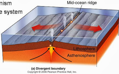
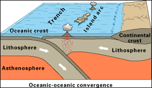
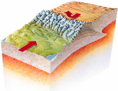
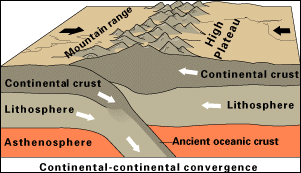
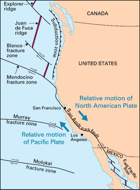
Geologists now know that the Earth's outermost layer, the lithosphere, is divided into independently moving plates into which the continents are embedded. The plates "float" on a layer called the athenosphere. There are different types of plate boundary. Spreading centres at mid-ocean ridges are where undersea volcanoes create new plate material. Subduction zones are where one plate sinks below another, causing volcanic eruptions and earthquakes and, sometimes, building mountains.
The lithosphere is broken up into tectonic plates. On Earth, there are seven or eight major plates (depending on how they are defined) and many minor plates. Where plates meet, their relative motion determines the type of boundary: convergent, divergent, or transform. Earthquakes, volcanic activity, mountain-building, and oceanic trench formation occur along these plate boundaries. The lateral relative movement of the plates typically varies from zero to 100 mm annually.
Tectonic plates are composed of oceanic lithosphere and thicker continental lithosphere, each topped by its own kind of crust. Along convergent boundaries, subduction carries plates into the mantle; the material lost is roughly balanced by the formation of new (oceanic) crust along divergent margins by seafloor spreading. In this way, the total surface of the globe remains the same. This prediction of plate tectonics is also referred to as the conveyor belt principle. Earlier theories (that still have some supporters) proposed gradual shrinking (contraction) or gradual expansion of the globe.
Tectonic plates are able to move because the Earth's lithosphere has a higher strength than the underlying asthenosphere. Lateral density variations in the mantle result in convection. Plate movement is thought to be driven by a combination of the motion of the seafloor away from the spreading ridge (due to variations in topography and density of the crust, which result in differences in gravitational forces) and drag, downward suction, at the subduction zones. Another explanation lies in the different forces generated by the rotation of the globe and the tidal forces of the Sun and the Moon. The relative importance of each of these factors is unclear, and is still subject to debate.
Pangaea begins to break up was a supercontinent that existed during the late Paleozoic and early Mesozoic eras, forming about 300 million years ago. It began to break apart around 200 million years ago. The single global ocean which surrounded Pangaea is accordingly named Panthalassa.
The driving force behind plate tectonics is a combination of pushing from mid-ocean ridges and pulling at subduction zones, researchers think. Scientists continue to study and debate the mechanisms that move the plates.
Mid-ocean ridges are gaps between tectonic plates that mantle the Earth like seams on a baseball. Hot magma wells up at the ridges, forming new ocean crust and shoving the plates apart. At subduction zones, two tectonic plates meet and one slides beneath the other back into the mantle, the layer underneath the crust. The cold, sinking plate pulls the crust behind it downward.
Many spectacular volcanoes are found along subduction zones, such as the "Ring of Fire" that surrounds the Pacific Ocean.
Early 20th century geologist Alfred Wegener realised that the puzzle-like fit of many the continents was more than a coincidence, but he couldn't correctly explain what powered their movement.
 |
| Earth's plates float on a sea of molten rocks |
Geologists now know that the Earth's outermost layer, the lithosphere, is divided into independently moving plates into which the continents are embedded. The plates "float" on a layer called the athenosphere. There are different types of plate boundary. Spreading centres at mid-ocean ridges are where undersea volcanoes create new plate material. Subduction zones are where one plate sinks below another, causing volcanic eruptions and earthquakes and, sometimes, building mountains.
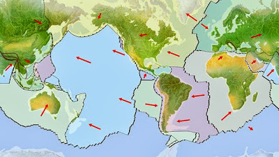 |
| Earth's tectonic plates with arrows indicating motion |
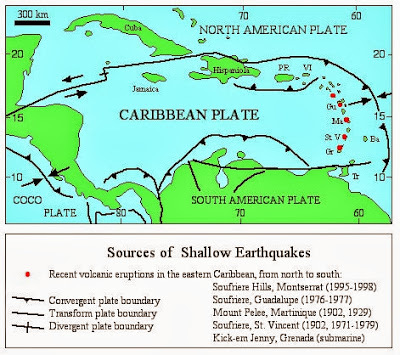
The lithosphere is broken up into tectonic plates. On Earth, there are seven or eight major plates (depending on how they are defined) and many minor plates. Where plates meet, their relative motion determines the type of boundary: convergent, divergent, or transform. Earthquakes, volcanic activity, mountain-building, and oceanic trench formation occur along these plate boundaries. The lateral relative movement of the plates typically varies from zero to 100 mm annually.
Tectonic plates are composed of oceanic lithosphere and thicker continental lithosphere, each topped by its own kind of crust. Along convergent boundaries, subduction carries plates into the mantle; the material lost is roughly balanced by the formation of new (oceanic) crust along divergent margins by seafloor spreading. In this way, the total surface of the globe remains the same. This prediction of plate tectonics is also referred to as the conveyor belt principle. Earlier theories (that still have some supporters) proposed gradual shrinking (contraction) or gradual expansion of the globe.
Tectonic plates are able to move because the Earth's lithosphere has a higher strength than the underlying asthenosphere. Lateral density variations in the mantle result in convection. Plate movement is thought to be driven by a combination of the motion of the seafloor away from the spreading ridge (due to variations in topography and density of the crust, which result in differences in gravitational forces) and drag, downward suction, at the subduction zones. Another explanation lies in the different forces generated by the rotation of the globe and the tidal forces of the Sun and the Moon. The relative importance of each of these factors is unclear, and is still subject to debate.
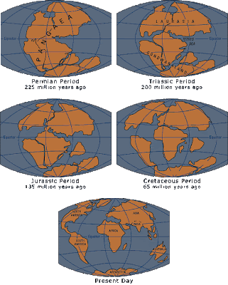 |
| plates movement |
Pangaea begins to break up was a supercontinent that existed during the late Paleozoic and early Mesozoic eras, forming about 300 million years ago. It began to break apart around 200 million years ago. The single global ocean which surrounded Pangaea is accordingly named Panthalassa.
The driving force behind plate tectonics is a combination of pushing from mid-ocean ridges and pulling at subduction zones, researchers think. Scientists continue to study and debate the mechanisms that move the plates.
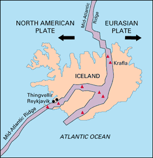
Mid-ocean ridges are gaps between tectonic plates that mantle the Earth like seams on a baseball. Hot magma wells up at the ridges, forming new ocean crust and shoving the plates apart. At subduction zones, two tectonic plates meet and one slides beneath the other back into the mantle, the layer underneath the crust. The cold, sinking plate pulls the crust behind it downward.
Many spectacular volcanoes are found along subduction zones, such as the "Ring of Fire" that surrounds the Pacific Ocean.



No comments:
Post a Comment